Politics
Indian Edition
UN Gets Its Map, India Gets Its Red Lines, Kashmir and Ladakh Stay Non Negotiable
The report presents India support for the UN map resolution alongside its firm position on Jammu and Kashmir and Ladakh, giving prominence to India’s territorial stance. It provides less emphasis on…
CMS Admin
Editorial · Honestly Biased
AI Narrative Bias Audit
The headline is mildly nationalistic in framing, emphasizing India’ firm territorial stance while giving less attention to the broader UN resolution and its international context.
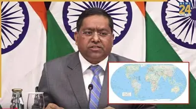
New Delhi- India has voted in favour of a United Nations General Assembly resolution promoting the use of equal area world map projections, while making it clear that any depiction of its sovereign territory, including the Union Territories of Jammu and Kashmir and Ladakh, must conform to India official map.
The resolution, adopted on September 4, seek to encourage a more accurate representation of the relative size of the world continental landmasses. India supported the measure but clarified that its vote should not be interpreted as endorsing any particular world map, cartographic projection or representation of national boundaries.
India Clarifies Position on the UN Map
India statement came two days after it voted in favour of the UN General Assembly resolution titled Correct the Map, Rebalancing Global Cartographic Representation and Promoting Equitable Representation of the World Regions, Particularly Africa.
The resolution was sponsored by Togo and received 164 votes in favour. Six countries Estonia, Georgia, Lithuania, Moldova, Serbia and Ukraine abstained, while the United States was the only country to vote against it.
The measure focuses primarily on cartographic representation and seeks to promote map projections that preserve the relative size of continental landmasses.
New Delhi Says Vote Does Not Endorse a Specific Map
Ministry of External Affairs spokesperson Randhir Jaiswal said India support for the resolution was based on the principle of promoting equal area cartographic representation.
Jaiswal clarified that the resolution does not adopt or authenticate a specific world map. He also said the measure does not deal with political cartography, including international boundaries, disputed territories or place names.
This distinction was important for New Delhi because maps can carry political as well as geographical implications, particularly when they depict territories whose status is contested.
Firm Position on Jammu and Kashmir and Ladakh
While supporting the broader objective of improving global cartographic representation, India stressed that its sovereign territory must be shown according to its official map.
New Delhi specifically referred to the Union Territories of Jammu and Kashmir and Ladakh, stating that any inaccurate or misleading representation would be unacceptable.
India reiterated that its position regarding sovereignty and territorial integrity remain unchanged and said the issue was not being altered by its vote on the UN resolution.
What the UN Resolution Seeks to Change
The resolution is centred on the way the world is represented through maps, particularly the use of projections that can distort the apparent size of continents.
Equal area projections are designed to preserve the relative area of landmasses, meaning that countries and continents are represented in proportion to their actual geographical size. This is different from projections that may prioritize other characteristics, such as navigation, shape or visual appearance.
The resolution title specifically highlights the need for more equitable representation of global regions, particularly Africa.
Resolution Does Not Decide Territorial Disputes
India also emphasized that the UN resolution does not determine how disputed territories should be represented.
According to the Ministry of External Affairs, the resolution neither endorses a particular map nor addresses political questions involving international boundaries, disputed territories or place names.
India clarification therefore separates its support for the cartographic principle behind the resolution from its longstanding position on territorial sovereignty.
Why India's Clarification Matters
The issue demonstrates how a seemingly technical question about map projections can overlap with sensitive diplomatic and territorial concern.
For India, supporting a map projection that aims to provide a more geographically accurate representation does not mean accepting every political depiction that may appear on such maps.
By backing the resolution while simultaneously outlining its position on Jammu and Kashmir and Ladakh, New Delhi has sought to make clear that its vote concerns cartographic accuracy and equal area representation, rather than recognition of any particular political map.
International Vote
The overwhelming vote in favour of the resolution reflected broad support among UN member states for improving the geographical representation of the world regions.
The measure received 164 votes in favour, while six countries abstained and the United States voted against it.
However, the resolution itself does not establish a new international position on territorial boundaries. India statement underlined that distinction while reaffirming New Delhi position on its sovereign territory.
India Maintains Its Position
India vote in favour of the UN resolution marks support for a broader effort to improve how the world landmasses are represented on maps.
At the same time, New Delhi has drawn a clear distinction between cartographic projection and political representation of territory. India maintains that Jammu and Kashmir and Ladakh must be depicted in accordance with its official map and that any representation it considers inaccurate or misleading is unacceptable.
The UN resolution, meanwhile, remain focused on encouraging equal-area map projection and does not itself authenticate a particular map or settle questions concerning international boundaries and disputed territorie.
Distribute This Chronicle
Independent commentary breaks corporate silence when readers circulate the ledger directly to their peers.
Attribution: Editorial
Examine Raw Source